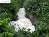
7/6/2013 - with all the rain we've had lately, I just HAD to get out and see how it affected these falls. The change was SPECTACULAR!
5/26/2013 - drove up US 64 out of Franklin to get videos of the falls along the Cullasaja River
8/6/2011 - since most of the falls I still want to see in Georgia require a hike to get to, and since it's so darn HOT right now...my sister and I decided to range out a little further and check out some falls in North Carolina. Several times over the last few weeks, people have asked me if I've seen the falls in the area of Highlands, NC. I decided to check them out. Talk about spectacular falls, wow!
We started by driving north on US 441 to Franklin, NC and then east on US 64. When we got to Highlands we just kept driving east on several different roads and found some gorgeous cliffs and a couple of waterfalls we weren't originally looking for. From Franklin, along US 64, there are 4 waterfalls that are right by the road and only one of them requires a short hike to see, though even that one can be viewed from a new wheelchair accessible overlook deck.
The first falls is Cullasaja Falls. The main falls is the most visible, but the upper falls can just be glimpsed through a "hole" in the trees along the road. Most websites say these are 7.7 miles from the exit where US 64 turns east away from US 441, but my odometer put it closer to 7.9 miles. The road is very narrow all along here, and there is a paved pull-off beside the guard-rail, but it's small, maybe room for 4 or 5 cars at most. On the day we were there it was hot, and there were lots of sighseers out, so the parking was tight and busy.
GPS: 35°7'3"N 83°16'14"W
After heavy rain, July 2013
This falls is a small one that I just happened to a catch a glimpse of, so I went back and took photos and a video. There's a small pull off just past it, so you have to walk back down the road to see it. And there is NO verge, so you also have to keep an eye on the traffic.
I didn't get this one after the heavy rain...too much traffic to stop.
GPS: 35.11530°N 83.26710°W
This falls is about 2.5 miles further east from Cullasaja Falls and again there is a small parking area along the guard rail. This one has several names, but the best known one is "Bust Your Butt Falls"! There's a steep, eroded trail down to the base of the falls - but we didn't have the nerve to try it.
GPS: 35°5'34"N 83°15'56"W
After heavy rain, July 2013
The next falls is Dry Falls. This is a VERY popular spot, and there is a large parking area and what looks like a newish, wheelchair accessible viewing deck. There's also a switch-backed trail down to the falls and you can walk under them.
GPS: 35°4'4"N 83°14'18"W
I couldn't do the hike down to get closer for the video, didn't think my sore leg could stand it...so I took the video from the easy access view deck up at the parking
After heavy rain, July 2013
This one is about .8 miles from Dry Falls.
GPS: 35°4'18"N 83°13'44"W
After heavy rain, July 2013
After Bridal Veil Falls we continue to and through Highlands. US 64 makes a turn to the north here, but we just kept going straight through town on Main St. This then turned into Horse Cove Rd, then into Bull Pen Rd. Bull Pen Rd. switch-backed down the mountain into a high valley that ran along a spectacular line of distant white cliffs. You can various glimpses and views of these cliffs for quite a long distance as you drive.
Directions and Information: from Clayton, GA
- north on US 441 to Franklin, NC
- east on US 64, along Cullsaja River valley


No comments:
Post a Comment