What this is all about

I like to hike, and I belong to a womens hiking group called "TrailDames" - one of our hikes took us to a waterfall just over the border in South Carolina. This got me interested in finding waterfalls nearby and earlier this year I found a website with directions and photos of waterfalls in North Georgia at (see links for TrailDames & North Georgia Waterfalls below)

I now also belong to another womens hiking group called Off the Grid. Both OTG and Traildames are on Meetup.

Mr. Anthony's site has lovely photos of well over 100 waterfalls in North Georgia and I got interested in seeing them. As the weather got hotter through the summer I concentrated on shorter hikes to falls, and falls that were visible from the road. Then, as it started to get cooler again, I started doing longer hikes. It turned out to be far more fun than I expected it to be, and to my surprise - when I added them up - I had been to over 100 myself!

So I decided to make a record of them and of what it's like to visit them, in case anyone else is interested in seeing them too. I will be adding photos and directions, trail conditions, etc. in the future. As I "redo" falls I will update the page that already exists for them, instead of creating a new page every time. Keeping with the format of this blog site, I will put new information at the top of each existing page.

I won't be putting road mileages on the directions, I strongly urge you to compare my directions to a good map so you can see the distances for yourself. I'm not very good at guessing distances, so if I can find a trail length I will use that. If I'm guessing, I'll put a question mark so you'll know!

My apologies for the "watermarks" on the photos, but I have had...and know other people who have had...photos stolen off the net. The watermarks are to ensure that they can't be reused without being identified as mine.

I got a good GPS unit and I'll slowly be putting GPS coordinates for the falls, when I can. If I can get close to the falls the GPS will be for the falls. Otherwise, it will be for where you can see them most easily.

Nov 2012: I got a new PC and now that I can actually get things done (!) I'm going to rearrange the way the falls are listed. I'm going to list them separately, instead of grouping them by the day I saw them. The only ones I'll group are the ones that are on the same creek, or very close - like on the same road.

I've completed rearranging the posts. Hopefully this will help make the falls easier to find. I also found my count was WAY off, so I've updated the total too.

Jan 2013 - I just got a video camera, so I'll be adding short videos of the falls as I am able to get back to them. They might be a bit shakey at first, but hopefully I'll get better as I get used to using it!

Jan 2014 - I almost forgot about posting this! I had been in contact with Sharon Collins, the host of GPB's "Georgia Outdoors"...offering to take her around my 18 Waterfalls tour. She was not able to make it, but I did take her cameraman Shane Keating on the tour. I was hoping they'd do a show about the tour, but that didn't happen. However, some of the shots did show up in the episode "Mountain Magic"...so I've added a link to that episode.

Aug 2015 - I've created a Google map of the waterfalls I either have been to, or know about as publicly accessable, check it out at: https://goo.gl/maps/79Lyb

Got some additional news. The episode of Georgia Outdoors mentioned above, that has some of the shots taken by the cameraman on my 18 Wateralls tour...won a 2015 Southeastern Emmy for "Magazine Program" http://www.gpb.org/emmys

Total Falls

Total waterfalls as of 6/7/2015: 504
Total videos as of 6/7/2015: 180

Friday, November 22, 2013

Rhododendron Trail (6 falls)

3/8/2014 - went back to the Rhododendron Trail to try to get better videos of the distant falls.  I think I have them in the right order!  I realized as I was filming that there was an even lower one that I have missed on past trips.  So that increases the total to  6 falls, but now I don't have still shots of them all - guess I'll have to go back yet again!

11/22/2013 - took advantage of being off for over a week for the Thanksgiving holiday and went out to get videos of waterfalls.  Had time to take a good look at the distant falls, using the zoom on my video camera and I'm pretty sure they are 2 separate falls.  I was not able to get a good video of the upper falls, but the lower one came out ok.

1/25/2012 - my sister and I went back to the Rhododendron Trail at the Lake Russell end to scout the trail for a TrailDames hike and to get new pictures.  Got much better ones with the leaves off the trees!  And we found another one that I completely missed the first time I was there.  This time of the year the falls are much easier to spot.

6/26/2011 - stayed a bit closer to home this time and went up to the Lake Russell area to try the western half (or so) of the Rhododendron Trail, that starts in Cornelia and ends at the road down into the Lake Russell area.

There's no sign at this end for the trail, but it begins right at the sign that says "Fee Area ahead." (GPS: 34°30'5"N 83°29'23"W)  There's not any parking to speak of, but there's enough room on the verge for maybe 3 cars.  It's hard to tell there's a trail here, but when you look down from the road, you'll see a new wooden bridge and that's the trail

This was a pretty easy hike.  It does go steadily uphill along what looks like an old logging road, but none of the hills was really steep or long.  My GPS said I did just under 2 miles total, and it took me about 1 1/2 hours - and that includes stopping for photos, and bushwhacking over to the first falls.

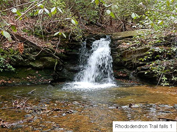
As you hike in, once you turn up the valley and get out of ear-shot of the road, you'll start to hear the sound of water.  Keep hiking until it gets about as loud as it's going to get, then bushwhack a short way to the left, to the creek, and there is a small falls there.

Cascade Falls is at about .71 miles and at about 1.03 miles (GPS: 34°30'31"N 83°30'0"W) is the narrow side trail, on the right, to the falls on the side creek.  Cascade Falls is hard to see in the photo, but as usual, is easier when you are there.  I'll have to go back after the leaves drop and see if I can get a better shot.

GMAPS does not show the names of the creek for these falls, but it flows into Lake Russell

GPS: 34°30'14"N 83°29'39"W

GPS: 34°30'20"N 83°29'48"W

GPS: 34°30'33"N 83°30'0"W
This video is of the bottom falls in the still photo...just to the right of the big tree on the left side.


At the Cornelia end of the Rhododendron Trail is this nice trail map.

 Directions and Information: from US 441/23 north of Gainesville
  • exit right onto GA 197
  • at bottom of exit ramp, turn right
  • road ends at T junction, turn right
  • left on Lake Russell Road
  • watch for small wooden bridge on right
  • park here

No comments: