What this is all about

I like to hike, and I belong to a womens hiking group called "TrailDames" - one of our hikes took us to a waterfall just over the border in South Carolina. This got me interested in finding waterfalls nearby and earlier this year I found a website with directions and photos of waterfalls in North Georgia at (see links for TrailDames & North Georgia Waterfalls below)

I now also belong to another womens hiking group called Off the Grid. Both OTG and Traildames are on Meetup.

Mr. Anthony's site has lovely photos of well over 100 waterfalls in North Georgia and I got interested in seeing them. As the weather got hotter through the summer I concentrated on shorter hikes to falls, and falls that were visible from the road. Then, as it started to get cooler again, I started doing longer hikes. It turned out to be far more fun than I expected it to be, and to my surprise - when I added them up - I had been to over 100 myself!

So I decided to make a record of them and of what it's like to visit them, in case anyone else is interested in seeing them too. I will be adding photos and directions, trail conditions, etc. in the future. As I "redo" falls I will update the page that already exists for them, instead of creating a new page every time. Keeping with the format of this blog site, I will put new information at the top of each existing page.

I won't be putting road mileages on the directions, I strongly urge you to compare my directions to a good map so you can see the distances for yourself. I'm not very good at guessing distances, so if I can find a trail length I will use that. If I'm guessing, I'll put a question mark so you'll know!

My apologies for the "watermarks" on the photos, but I have had...and know other people who have had...photos stolen off the net. The watermarks are to ensure that they can't be reused without being identified as mine.

I got a good GPS unit and I'll slowly be putting GPS coordinates for the falls, when I can. If I can get close to the falls the GPS will be for the falls. Otherwise, it will be for where you can see them most easily.

Nov 2012: I got a new PC and now that I can actually get things done (!) I'm going to rearrange the way the falls are listed. I'm going to list them separately, instead of grouping them by the day I saw them. The only ones I'll group are the ones that are on the same creek, or very close - like on the same road.

I've completed rearranging the posts. Hopefully this will help make the falls easier to find. I also found my count was WAY off, so I've updated the total too.

Jan 2013 - I just got a video camera, so I'll be adding short videos of the falls as I am able to get back to them. They might be a bit shakey at first, but hopefully I'll get better as I get used to using it!

Jan 2014 - I almost forgot about posting this! I had been in contact with Sharon Collins, the host of GPB's "Georgia Outdoors"...offering to take her around my 18 Waterfalls tour. She was not able to make it, but I did take her cameraman Shane Keating on the tour. I was hoping they'd do a show about the tour, but that didn't happen. However, some of the shots did show up in the episode "Mountain Magic"...so I've added a link to that episode.

Aug 2015 - I've created a Google map of the waterfalls I either have been to, or know about as publicly accessable, check it out at: https://goo.gl/maps/79Lyb

Got some additional news. The episode of Georgia Outdoors mentioned above, that has some of the shots taken by the cameraman on my 18 Wateralls tour...won a 2015 Southeastern Emmy for "Magazine Program" http://www.gpb.org/emmys

Total Falls

Total waterfalls as of 6/7/2015: 504
Total videos as of 6/7/2015: 180

Saturday, August 3, 2013

Sea Creek Falls

8/3/2013 - got up early and drove up Hwy 60 to go to Sea Creek Falls.  Got the falls below Woody Lake in Suches too.  With all the rain we've had this year, the trail to Sea Creek Falls looked as if it was doing it's best to become part of the creek!  Quite wet in places, with a few spots deep in mud.  It was possible to go in and keep my shoes clean, but it did take some weaving back and forth.

Then when I got to the falls I had to wade the creek to get the video.  The stepping stones that used to be there were gone, and the gravel bar was still there, but was under at least an inch of running water.

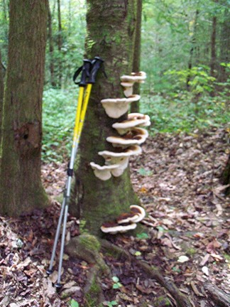
10/14/2011 - went back to Sea Creek Falls to get the GPS location.  I'm sorry to say that the fungus in the photo is no longer there.  I don't know if they died and fell off, or if someone pulled them off but I'm glad I at least have a photo of them.

The road was dry today, no huge puddle like the last time, so I drove across the creek and way down the road, but didn't see any other falls.

9/3/2010 This was my 2nd try as I misread Mr. Anthony's directions and went WAY too far down Hwy 60 towards Morganton,GA the first time.  I did it right this time!  This was an easy drive, once I did it correctly, but I couldn't get to the parking that is closest to the falls.  There was a HUGE deep puddle in the Forest Service road that I didn't want to drive through, so I parked there and hiked around it...but it only added a few hundred feet to the trip, so it wasn't a big deal.  The trail is easy to follow and some nice souls have put stepping stones in the creek so you can get out to the gravel bar that is the best view of the falls, without getting your feet wet.
GPS: 34°46'13"N 84°5'41"W
 
Directions and Information: from Dahlonega, GA
  • go north on US 19 bypass to Stone Pile Gap
  • turn left on GA 60
  • turn right on Cooper Creek Rd
  • turn left on FS 264
Note: there is a parking area about 2/10 mi down FS 264, but you might not be able to get there due to deep water-filled potholes in the road.  Park where you can be off the road, and just go on down the road to where you see a good sized parking area on the left.  Go over the blocking mounds, along the creek to the falls.  At an open wooded area along the creek before the falls, look to your right for some trees with HUGE fungus growths.  I didn't actually see these until I was coming back out.

Canada Creek falls (at Woody Lake)

8/3/2013 - got up early today, for a change, and drove up Hwy 60 (NOT my favorite road!) to get the falls below Woody Lake in Suches, and Sea Creek Falls.

9/2/2012 - went back up Hwy 60, through Suches and on to Rock Creek Rd, to get some falls I've heard in the past but didn't have time to track down to get photos. Got the falls below the dam at Woody Lake in Suches and then drove up Rock Creek Rd to get some falls above the fish hatchery and below the dam at Rock Creek Lake along there.
Falls below the dam at Woody Lake in Suches, GA. These are easily visible from Hwy 60, just before the junction with Hwy 180...but it's a narrow view between the trees and some kind of commercial building.

According to GMAPS the lake and this falls are on Canada Creek

GPS: 34.68741° -84.02170°


Directions and Information: from Dahlonega, GA

  • north on US 19
  • left onto Hwy 60 - to Suches, GA